Tag Archives: neighborhoods

Neighborhood Map (Masan-happo gu, Masan-hoewon gu)

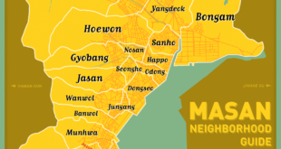
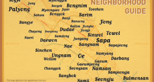
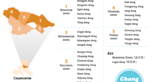
Continuing the task of mapping out Changwon’s neighborhoods (dongs), here is our map of central Masan, including Masan-happo gu and Masan-hoewon gu.  Unlike our central Changwon map, we were able to track down the actual neighborhood borders, thanks to the korean-language version of Masan’s wikipedia pages (1, 2).  For the …

Read More »

Neighborhood Map (Uichang gu, Seongsan gu)

We proudly present to you a map of neighborhoods (dong) in the central Changwon area (Uichang gu and Seongsan gu).  This map features the approximate locations of each neighborhood, using information gleaned from Google maps.  These neighborhoods are the smaller, colloquial dongs, as detailed in Changwon’s Neighborhood System, and thus, much …

Read More »

Changwon’s Neighborhood System

If you don’t have a handle on Korea’s administrative divisions, please read our article on that topic first. Changwon (according to its website) has a population nearing 1.1 million people.  In 2010, it incorporated the bordering cities Jinhae and Masan.  Consequentially, has undergone redistricting to accommodate its larger size. At the highest level, the city is divided …

Read More »