Changwonderful
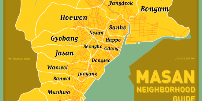


Continuing the task of mapping out Changwon’s neighborhoods (dongs), here is our map of central Masan, including Masan-happo gu and Masan-hoewon gu. Unlike our central Changwon map, we were able to track down the actual neighborhood borders, thanks to the korean-language version of Masan’s wikipedia pages (1, 2). For the sake of simplification, neighborhoods that are normally subdivided (Hapseong 1 dong and Hapseong 2 dong, for example) are combined in this map.
Furthermore, please note that smaller administrative districts are not included on this map. For example, Chang dong is considered a part of Dongseo dong, and therefore fits within Dongseo’s administration. Even more complicating, some of these smaller dongs are spread between the borders of multiple larger dongs. Depicting these areas with their borders is near impossible. However, if a solution can be found, expect this map to be updated.
Daegeori, Masan train station, and Bongam reservoir are included in red for the sake of orientation.
If you want to see Jinhae or the surrounding country sides, look out for these in the future maps!